2024 Map of Alturas
USGS Topo · Published 2024About this map
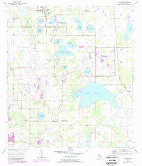
Alturas serves as the central hub for this interior Florida landscape, where a dense network of lakes and drainage systems defines the local geography. Large bodies of water like Lake Buffum and Lake Henry dominate the southern portion of the quadrangle, while the northern section is characterized by smaller named basins including Crystal Lake, Perch Lake, and Gadau Lake. The intricate water management of the region is evident in the Peace Creek Drainage Canal, which cuts across the northeastern corner.
Find a feature on this map
111 named features on this map. Tap any name to fly to it.
Don’t see what you’re looking for? This feature index may not catch every label — zoom into the map to look around manually.
Map Details
Editions of this 2024 Alturas Map
This is the sole edition of this map. No revisions or reprints were ever made.