1889 Map of Amana
USGS Topo · Published 1896About this map
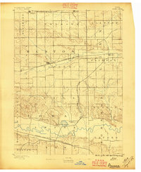
The communal settlements of the Amana Colonies are documented here in late 19th-century detail, clustered along the Iowa River valley. This 1888 survey reveals the distinct arrangement of the seven villages, including Amana, Middle Amana, West Amana, and the uniquely named Hohe Amana, showing their proximity to fertile bottomlands and established water routes. The landscape is defined by the transition from the river basin to the northern uplands where Prairie Creek flows toward Fairfax.
Find a feature on this map
33 named features on this map. Tap any name to fly to it.
Don’t see what you’re looking for? This feature index may not catch every label — zoom into the map to look around manually.
Map Details
Editions of this 1889 Amana Map
2 editions found
Other maps of this area

1887 · Cedar Rapids
USGS Topo · 1:62,500

1888 · Shellsburg
USGS Topo · 1:62,500

1888 · Marion
USGS Topo · 1:62,500

1888 · Amana
USGS Topo · 1:62,500

1889 · Marion
USGS Topo · 1:62,500

1889 · Amana
USGS Topo · 1:62,500

1889 · Shellsburg
USGS Topo · 1:62,500

1891 · Oxford
USGS Topo · 1:62,500

1891 · Cedar Rapids
USGS Topo · 1:62,500

1891 · Iowa City
USGS Topo · 1:62,500