
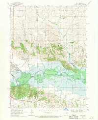
1968 Map of Amana
USGS Topo · Published 1978About this map
Amana and its neighboring colonies of East Amana and Homestead anchor this mid-century survey, showcasing the enduring settlement patterns and industrial infrastructure of the Amana Colonies. The landscape is defined by the sweeping curves of the Iowa River and the significant reach of Coralville Lake, which dominates the central and eastern portions of the map. Traces of the region's agricultural and communal history are visible in local landmarks like the Powerplant and Townhall, while rural family history is preserved at Hala Cem, Castek Cem, and Brown Cem.
Find a feature on this map
33 named features on this map. Tap any name to fly to it.
Don’t see what you’re looking for? This feature index may not catch every label — zoom into the map to look around manually.
Map Details
Editions of this 1968 Amana Map
2 editions found
Other maps of this area

1887 · Cedar Rapids
USGS Topo · 1:62,500

1888 · Amana
USGS Topo · 1:62,500

1889 · Amana
USGS Topo · 1:62,500

1891 · Oxford
USGS Topo · 1:62,500

1891 · Cedar Rapids
USGS Topo · 1:62,500

1891 · Iowa City
USGS Topo · 1:62,500

1894 · Oxford
USGS Topo · 1:62,500

1899 · Amana
USGS Topo · 1:62,500

1903 · Fairfax
USGS Topo · 1:125,000

1938 · Iowa City
USGS Topo · 1:62,500