1968 Map of Amana
USGS Topo · Published 1971About this map
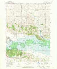
The Iowa River valley dominates this late-1960s landscape, featuring the expansive Coralville Reservoir at the heart of the region. The map captures the distinct settlement patterns of the Amana Colonies, with Amana and East Amana positioned north of the river and Homestead to the south. Transport and industrial infrastructure are evident through the Chicago Milwaukee St Paul and Pacific railroad lines and a Powerplant near the river bend. Local history is preserved in rural markers such as Hala Cem, Castek Cem, and the Townhall in Monroe township. The area's geography is further detailed by numerous water bodies like Holdens Pond and Matson Pond, along with the winding course of Price Creek, illustrating the complex water management and natural drainage systems surrounding the reservoir.
Find a feature on this map
34 named features on this map. Tap any name to fly to it.
Don’t see what you’re looking for? This feature index may not catch every label — zoom into the map to look around manually.
Map Details
Editions of this 1968 Amana Map
2 editions found

Other maps of this area

1887 · Cedar Rapids
USGS Topo · 1:62,500

1888 · Amana
USGS Topo · 1:62,500

1889 · Amana
USGS Topo · 1:62,500

1891 · Oxford
USGS Topo · 1:62,500

1891 · Cedar Rapids
USGS Topo · 1:62,500

1891 · Iowa City
USGS Topo · 1:62,500

1894 · Oxford
USGS Topo · 1:62,500

1899 · Amana
USGS Topo · 1:62,500

1903 · Fairfax
USGS Topo · 1:125,000
1938 · Iowa City
USGS Topo · 1:62,500