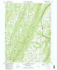
1994 Map of Amaranth
USGS Topo · Published 1997About this map
The boundary between Bedford and Fulton Counties defines the spine of this ridge-and-valley landscape, where high elevations like Rays Hill and Sideling Hill separate small, tucked-away rural communities. Small settlements like Robinsonville and Amaranth serve as local anchors along the winding road network, interspersed with historic congregational markers such as Shreves Chapel and Wards Ch. The terrain is deeply carved by drainage systems including Sideling Hill Creek and Brush Creek, which dictate the placement of early infrastructure like the Ford near Purcell.
Find a feature on this map
53 named features on this map. Tap any name to fly to it.
Don’t see what you’re looking for? This feature index may not catch every label — zoom into the map to look around manually.
Map Details
Editions of this 1994 Amaranth Map
This is the sole edition of this map. No revisions or reprints were ever made.
Other maps of this area

1898 · Paw Paw
USGS Topo · 1:62,500

1899 · Hancock
USGS Topo · 1:62,500

1900 · Pawpaw
USGS Topo · 1:62,500

1901 · Hancock
USGS Topo · 1:62,500

1910 · Paw Paw
USGS Topo · 1:62,500

1925 · Needmore
USGS Topo · 1:48,000

1927 · Clearville
USGS Topo · 1:48,000

1931 · Clearville
USGS Topo · 1:62,500

1935 · Needmore
USGS Topo · 1:62,500

1939 · Needmore
USGS Topo · 1:62,500
Featured Places
- Bethel Township, PA
- Union Township, PA
- Mann Township, PA
- Brush Creek Township, PA
- Point View, Union Township