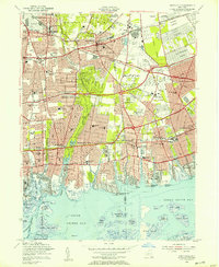
1954 Map of Amityville
USGS Topo · Published 1957About this map
The Long Island Railroad cuts across this mid-century landscape, linking established hubs like Amityville and Farmingdale with the burgeoning postwar suburbs of Massapequa and Levittown. The map reveals a fascinating concentration of aviation and education infrastructure, from the industrial Grumman Airfield and Republic Airfield to the Long Island Agricultural and Technical Institute. South of the Southern State Parkway, the terrain gives way to a complex network of coastal inlets and marshes, including Massapequa Lake and the various islands of South Oyster Bay. This era is particularly defined by its massive memorial grounds in the northeast, where the contiguous borders of St Charles Cemetery, Pinelawn Cemetery, and Beth Moses Cemetery create one of the most significant cemetery complexes in the region. The map meticulously documents the transition from open Bethpage State Park lands to the dense residential grids that would eventually define the Long Island shoreline.
Find a feature on this map
116 named features on this map. Tap any name to fly to it.
Don’t see what you’re looking for? This feature index may not catch every label — zoom into the map to look around manually.
Map Details
Editions of this 1954 Amityville Map
This is the sole edition of this map. No revisions or reprints were ever made.
Other maps of this area

1897 · Hempstead
USGS Topo · 1:62,500

1897 · Oyster Bay
USGS Topo · 1:62,500

1898 · Hempstead
USGS Topo · 1:62,500

1898 · Oyster Bay
USGS Topo · 1:62,500

1899 · Hempstead
USGS Topo · 1:62,500

1900 · Oyster Bay
USGS Topo · 1:62,500

1901 · Babylon
USGS Topo · 1:62,500

1901 · Northport
USGS Topo · 1:62,500

1903 · Babylon
USGS Topo · 1:62,500

1903 · Northport
USGS Topo · 1:62,500