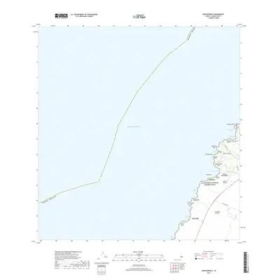
2017 Map of Anaehoomalu
USGS Topo · Published 2017About this map
The Lava Flow of 1859 dominates the southern coastal landscape of this portion of the Island of Hawai'i, where volcanic history meets the edge of the Pacific Ocean. This survey documents a transition from the barren lava fields to the developing resort areas near Anaehoomalu Bay. Along the shoreline, the Ala Kahakai National Historic Trail threads through a series of traditional coastal settlements and landmarks, including Kapalaoa and Keawaiki. The map illustrates a coastline defined by numerous indentations such as Waiulua Bay, Pueo Bay, and Ohiki Bay. While modern roads like Waikoloa Beach Dr and Puu Pohaku Rd provide inland access, the ancient trail remains a primary corridor for navigating the small points and landings, such as Lulahala Point and Anaehoomalu Point, that have long served as local orientation markers.
Find a feature on this map
34 named features on this map. Tap any name to fly to it.
Don’t see what you’re looking for? This feature index may not catch every label — zoom into the map to look around manually.
Map Details
Editions of this 2017 Anaehoomalu Map
This is the sole edition of this map. No revisions or reprints were ever made.
Other maps of this area

1913 · Kohala
USGS Topo · 1:62,500

1916 · Kohala
USGS Topo · 1:62,500

1928 · Puako
USGS Topo · 1:62,500

1954 · Hawaii North
USGS Topo · 1:250,000

1956 · Puu Hinai
USGS Topo · 1:24,000

1956 · Kawaihae
USGS Topo · 1:24,000

1959 · Hawaii North
USGS Topo · 1:250,000

1959 · Kiholo
USGS Topo · 1:24,000
1959 · Anaehoomalu
USGS Topo · 1:24,000

1959 · Makalawena
USGS Topo · 1:24,000