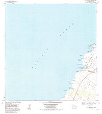
1982 Map of Anaehoomalu
USGS Topo · Published 1984About this map
The Lava Flow of 1859 dominates the southern landscape of this coastal Hawaii Island survey, reaching the shoreline at Keawaiki Bay. Along this portion of the Kona and Kohala coastlines, the Kings Highway traces a path through a series of volcanic fields, including the extensive Kaniku Lava Flow to the north. Settlement is concentrated in small coastal pockets such as Anaehoomalu and Keawaiki, where traditional Hawaiian land use is evident in the presence of the Kuualii Fishpond and Kahapapa Fishpond. The map captures the distinct boundary between the South Kohala District and North Kona District, while also showing the Puu Anahulu Homesteads (Kapalaoa Section) near Kapalaoa. This document records a landscape defined by recent geological activity and ancient coastal landmarks like Akahu Kaimu and Weliweli.
Find a feature on this map
36 named features on this map. Tap any name to fly to it.
Don’t see what you’re looking for? This feature index may not catch every label — zoom into the map to look around manually.
Map Details
Editions of this 1982 Anaehoomalu Map
2 editions found
Other maps of this area

1913 · Kohala
USGS Topo · 1:62,500

1916 · Kohala
USGS Topo · 1:62,500

1928 · Puako
USGS Topo · 1:62,500

1954 · Hawaii North
USGS Topo · 1:250,000

1956 · Puu Hinai
USGS Topo · 1:24,000

1956 · Kawaihae
USGS Topo · 1:24,000

1959 · Hawaii North
USGS Topo · 1:250,000

1959 · Kiholo
USGS Topo · 1:24,000
1959 · Anaehoomalu
USGS Topo · 1:24,000

1959 · Makalawena
USGS Topo · 1:24,000