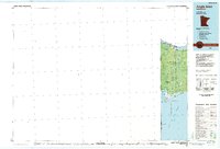
1985 Map of Angle Inlet
USGS Topo · Published 1985About this map
Angle Inlet and the northernmost reaches of Minnesota are documented here at the edge of the international border with Canada. This map focuses on the unique geography of the Northwest Angle, where the Red Lake Indian Reservation and Northwest Angle State Forest dominate the landscape. The planimetric detail emphasizes the isolation of this region, reachable primarily by water or through Manitoba. Small localized features such as Carlson Airfield and Sandy Beach provide evidence of the area's light human footprint amidst the expansive Lake of the Woods. The terrain is characterized by intricate shorelines including Sand Point Bay and Stony Point, along with the low-lying Calibou Bog. This survey captures the jurisdictional complexity of the Kenora District, Ontario and Lake of the Woods County, Minnesota boundary line cutting through the water.
Find a feature on this map
13 named features on this map. Tap any name to fly to it.
Don’t see what you’re looking for? This feature index may not catch every label — zoom into the map to look around manually.
Map Details
Editions of this 1985 Angle Inlet Map
2 editions found
Other maps of this area

1918 · Goos
USGS Topo · 1:62,500

1918 · Buffalo Bay
USGS Topo · 1:62,500

1918 · Roosevelt
USGS Topo · 1:62,500
1918 · Oak Island
USGS Topo · 1:62,500

1918 · Williams
USGS Topo · 1:62,500

1918 · Roseau
USGS Topo · 1:62,500

1918 · Warroad
USGS Topo · 1:62,500

1919 · Badger
USGS Topo · 1:62,500

1943 · Roosevelt
USGS Topo · 1:62,500

1943 · Goos
USGS Topo · 1:62,500