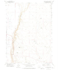
1971 Map of Antelope Butte
USGS Topo · Published 1975About this map
Guano Rim dominates this high-desert landscape in southeastern Oregon, forming a dramatic escarpment that separates the elevated plateau from the broad Guano Valley below. This 1971 survey captures a remote region defined by its water sources and topography, where the Doherty Slide marks a significant geologic break in the rim. Landmarks like the Langslet Monument Rest Area indicate human presence along the highway corridor, while the interior is dotted with critical watering points such as Snake Eyes Spring, Lane Spring, and Slide Waterhole. The land is shaped by volcanic features like Antelope Butte and Sage Hen Butte, with the drainage of Sage Hen Creek cutting through the sagebrush-covered terrain. A scattering of Borrow Pits and a Gravel Pit suggest localized road maintenance and resource extraction during this era.
Find a feature on this map
19 named features on this map. Tap any name to fly to it.
Don’t see what you’re looking for? This feature index may not catch every label — zoom into the map to look around manually.
Map Details
Editions of this 1971 Antelope Butte Map
This is the sole edition of this map. No revisions or reprints were ever made.
Other maps of this area

1889 · Long Valley
USGS Topo · 1:250,000

1954 · Vya
USGS Topo · 1:250,000

1955 · Adel
USGS Topo · 1:250,000

1957 · Adel
USGS Topo · 1:250,000

1958 · Vya
USGS Topo · 1:250,000

1958 · Adel
USGS Topo · 1:250,000

1962 · Vya
USGS Topo · 1:250,000

1962 · Adel
USGS Topo · 1:250,000

1966 · Catnip Canyon
USGS Topo · 1:24,000
1966 · Rye Creek
USGS Topo · 1:24,000