
1966 Map of Catnip Canyon
USGS Topo · Published 1968About this map
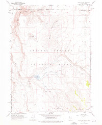
Charles Sheldon Antelope Range defines this high-desert landscape during the mid-1960s, straddling the remote high plateau where Nevada and Oregon meet. The survey details a critical wildlife conservation area within the Sheldon National Antelope Refuge, dominated by the drainage system of Catnip Creek and its branches, North Catnip Creek and South Catnip Creek. Water is the primary driver of life and activity here, evidenced by the central Catnip Reservoir and numerous vital water sources like Little Catnip Spring and East Spring. The topography transitions from the dramatic Rock Springs Table down into Catnip Canyon, while the western edge reaches toward the Guano Valley. Ranching and wildlife management infrastructure is noted through various fence lines and unimproved dirt roads that navigate the heights of Catnip Mtn and the shoreline of Round Mountain Lake.
Find a feature on this map
19 named features on this map. Tap any name to fly to it.
Don’t see what you’re looking for? This feature index may not catch every label — zoom into the map to look around manually.
Map Details
Editions of this 1966 Catnip Canyon Map
2 editions found
Other maps of this area

1889 · Long Valley
USGS Topo · 1:250,000

1954 · Vya
USGS Topo · 1:250,000

1955 · Adel
USGS Topo · 1:250,000

1957 · Adel
USGS Topo · 1:250,000

1958 · Vya
USGS Topo · 1:250,000

1958 · Adel
USGS Topo · 1:250,000

1962 · Vya
USGS Topo · 1:250,000

1962 · Adel
USGS Topo · 1:250,000

1966 · Bald Mountain
USGS Topo · 1:24,000
1966 · Rye Creek
USGS Topo · 1:24,000