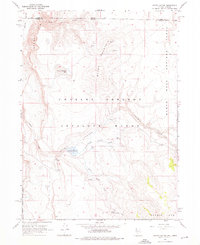
1966 Map of Catnip Canyon
USGS Topo · Published 1976About this map
The Charles Sheldon Antelope Range and Sheldon National Antelope Refuge dominate this high-desert landscape along the border of Nevada and Oregon. This mid-1960s survey documents a rugged wildlife sanctuary defined by its volcanic plateaus and seasonal water sources, which were vital for conservation efforts in the Great Basin. Large geological features like the Rock Springs Table and North Rock Springs Table overlook the drainage basins of Catnip Creek and its tributaries.
Find a feature on this map
23 named features on this map. Tap any name to fly to it.
Don’t see what you’re looking for? This feature index may not catch every label — zoom into the map to look around manually.
Map Details
Editions of this 1966 Catnip Canyon Map
2 editions found
Other maps of this area

1889 · Long Valley
USGS Topo · 1:250,000

1954 · Vya
USGS Topo · 1:250,000

1955 · Adel
USGS Topo · 1:250,000

1957 · Adel
USGS Topo · 1:250,000

1958 · Vya
USGS Topo · 1:250,000

1958 · Adel
USGS Topo · 1:250,000

1962 · Vya
USGS Topo · 1:250,000

1962 · Adel
USGS Topo · 1:250,000

1966 · Catnip Canyon
USGS Topo · 1:24,000

1966 · Bald Mountain
USGS Topo · 1:24,000