
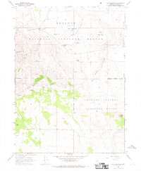
1966 Map of Bald Mountain
USGS Topo · Published 1968About this map
Sheldon Antelope National Refuge dominates this high-desert landscape in northern Washoe County, as it appeared in the mid-1960s. The map illustrates a remote environment managed for wildlife conservation, where human presence is marked by isolated landmarks like the Last Chance Ranch and an adjacent Landing Strip. The terrain is characterized by high peaks and ridges, including Bald Mountain, Mule Mountain, and Yellow Pk, which give way to seasonal water sources and livestock features such as Buck Pasture. The distribution of water is critical in this arid region, documented through numerous named springs such as Miller and Lux Spring, Hobble Springs, and Tuffy Springs. While much of the area is dedicated to the refuge and the Charles Sheldon Antelope Range, evidence of mineral exploration is visible at several Prospects located near Bald Mountain Canyon.
Find a feature on this map
25 named features on this map. Tap any name to fly to it.
Don’t see what you’re looking for? This feature index may not catch every label — zoom into the map to look around manually.
Map Details
Editions of this 1966 Bald Mountain Map
2 editions found
Other maps of this area

1889 · Long Valley
USGS Topo · 1:250,000

1954 · Vya
USGS Topo · 1:250,000

1958 · Vya
USGS Topo · 1:250,000

1962 · Vya
USGS Topo · 1:250,000

1966 · Catnip Canyon
USGS Topo · 1:24,000
1966 · Rye Creek
USGS Topo · 1:24,000

1966 · Swan Lake
USGS Topo · 1:24,000

1966 · Badger Mtn NW
USGS Topo · 1:24,000

1966 · Massacre Lake NW
USGS Topo · 1:24,000

1966 · Massacre Lake
USGS Topo · 1:24,000