
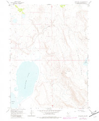
1966 Map of Massacre Lake
USGS Topo · Published 1968About this map
Massacre Lake and the smaller Middle Lake dominate the southwestern basin of this high-desert region in Washoe County. The landscape is defined by the sharp elevation changes of Bitner Table and the prominent Table Butte to the east, reflecting a terrain shaped by volcanic activity and seasonal water flow. Human presence is sparse, represented primarily by Evans Camp and a network of Jeep Trails and unnamed trails that navigate the ridgelines and plateaus. These paths connect various water sources essential for survival in the arid environment, such as Fatty Martin Lake and isolated springs. The 1966 field check reveals a remote pocket of Nevada where the economy and movement were tied to the available water and natural topography, with a lone Gravel Pit near the southern boundary indicating minor industrial activity.
Find a feature on this map
14 named features on this map. Tap any name to fly to it.
Don’t see what you’re looking for? This feature index may not catch every label — zoom into the map to look around manually.
Map Details
Editions of this 1966 Massacre Lake Map
2 editions found
Other maps of this area

1889 · Long Valley
USGS Topo · 1:250,000

1954 · Vya
USGS Topo · 1:250,000

1958 · Vya
USGS Topo · 1:250,000

1962 · Vya
USGS Topo · 1:250,000

1966 · Bald Mountain
USGS Topo · 1:24,000

1966 · Swan Lake
USGS Topo · 1:24,000

1966 · Badger Mtn NW
USGS Topo · 1:24,000

1966 · Massacre Lake NW
USGS Topo · 1:24,000

1966 · Nut Mountain
USGS Topo · 1:24,000
1966 · Calcutta Lake
USGS Topo · 1:24,000