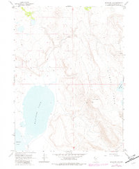
1966 Map of Massacre Lake
USGS Topo · Published 1982About this map
Massacre Lake and Middle Lake anchor this high-desert landscape in northwest Nevada, where the water levels of these intermittent basins define the local geography. The 1960s survey, updated in the early 1980s, reveals a sparse human presence marked primarily by Evans Camp and an extensive network of Jeep Trails used for land management and ranching access. The terrain is dominated by the dramatic rise of Bitner Table and Table Butte, where volcanic geology creates flat-topped mesas overlooking the lake beds below. Small water sources like Patty Martin Lake, a Spring, and a Seep highlight the critical importance of localized hydrology in this arid region of Washoe County. This sheet captures a moment when the area remained largely undeveloped, used primarily for livestock grazing and seasonal passage.
Find a feature on this map
12 named features on this map. Tap any name to fly to it.
Don’t see what you’re looking for? This feature index may not catch every label — zoom into the map to look around manually.
Map Details
Editions of this 1966 Massacre Lake Map
2 editions found
Other maps of this area

1889 · Long Valley
USGS Topo · 1:250,000

1954 · Vya
USGS Topo · 1:250,000

1958 · Vya
USGS Topo · 1:250,000

1962 · Vya
USGS Topo · 1:250,000

1966 · Bald Mountain
USGS Topo · 1:24,000

1966 · Swan Lake
USGS Topo · 1:24,000

1966 · Badger Mtn NW
USGS Topo · 1:24,000

1966 · Massacre Lake NW
USGS Topo · 1:24,000

1966 · Massacre Lake
USGS Topo · 1:24,000

1966 · Nut Mountain
USGS Topo · 1:24,000