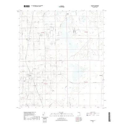
2018 Map of Anthony
USGS Topo · Published 2018About this map
The settlement of Sparr and the community of Anthony anchor this North Central Florida landscape, where the character of the terrain is defined by low-lying basins and ephemeral water bodies. This 2018 survey reveals a distinct pattern of land use, where aviation and agriculture meet at sites like Paniola Air Ranch Airport and Jumbolair Airport. The hydrography of the region is notably dominated by expansive open spaces such as Gooski Prairie, Black Sink Prairie, and Indian Lake Prairie, which indicate the natural drainage patterns characteristic of Marion County. Genealogists and local historians can locate established burial grounds, including Dupree Cem in the north and Mount Olive Cem near the center of the sheet. The map also traces the transition between rural residential growth and traditional land divisions, with smaller settlements like Oak and Burbank situated along the periphery of the more established townships.
Find a feature on this map
56 named features on this map. Tap any name to fly to it.
Don’t see what you’re looking for? This feature index may not catch every label — zoom into the map to look around manually.
Map Details
Editions of this 2018 Anthony Map
This is the sole edition of this map. No revisions or reprints were ever made.
Other maps of this area

1893 · Citra
USGS Topo · 1:62,500

1895 · Citra
USGS Topo · 1:62,500

1895 · Ocala
USGS Topo · 1:62,500

1954 · Gainesville
USGS Topo · 1:250,000

1954 · Daytona Beach
USGS Topo · 1:250,000

1958 · Daytona Beach
USGS Topo · 1:250,000

1958 · Gainesville
USGS Topo · 1:250,000

1959 · Gainesville
USGS Topo · 1:250,000

1964 · Daytona Beach
USGS Topo · 1:250,000
1967 · Citra
USGS Topo · 1:24,000