1959 Map of Gainesville
USGS Topo · Published 1959About this map
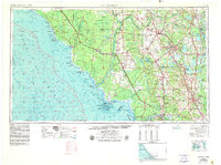
The Suwannee River carves a path through the heart of this North Florida landscape, connecting the interior forests to the Gulf of Mexico. Along the eastern corridor, the burgeoning city of Gainesville serves as a hub for the region, while farther south, Ocala anchors the inland citrus and ranching territory. This mid-century survey illustrates a complex network of railways, including the Seaboard Air Line and the Atlantic Coast Line, which supported the transport of timber and agricultural goods from remote outposts like Cross City and Trenton to larger markets. Along the coast, the intricate islands of the Cedar Keys National Wildlife Refuge and the fishing village of Cedar Key mark the transition from solid ground to the tidal marshes of Suwannee Sound. Significant water bodies like Orange Lake and Newmans Lake define the Alachua plains, highlighting a region defined by its diverse wetlands and early post-war development.
Find a feature on this map
86 named features on this map. Tap any name to fly to it.
Don’t see what you’re looking for? This feature index may not catch every label — zoom into the map to look around manually.
Map Details
Editions of this 1959 Gainesville Map
This is the sole edition of this map. No revisions or reprints were ever made.
Historical Maps of Gainesville Through Time
4 maps found