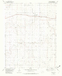
1982 Map of Arapahoe
USGS Topo · Published 1982About this map
Arapahoe sits as a lonely rail stop in the high plains of Cheyenne County, defined by the industrial presence of Storage Bins and the heavy transport of the Union Pacific railroad. The landscape is a study in western water management and resource extraction, characterized by an extensive network of irrigation wells and a prominent Gravel Pit along the southern drainage. The terrain is carved by the intermittent flows of the Smoky Hill River to the north and the split branches of Ladder Creek and North Fork Ladder Creek to the south. This 1982 survey captures the region as a critical agricultural and transportation corridor, where the straight lines of the railroad contrast with the winding, seasonal watercourses that have shaped the High Plains for generations.
Find a feature on this map
8 named features on this map. Tap any name to fly to it.
Don’t see what you’re looking for? This feature index may not catch every label — zoom into the map to look around manually.
Map Details
Editions of this 1982 Arapahoe Map
This is the sole edition of this map. No revisions or reprints were ever made.
Other maps of this area

1892 · Cheyenne Wells
USGS Topo · 1:125,000

1894 · Cheyenne Wells
USGS Topo · 1:125,000

1954 · Lamar
USGS Topo · 1:250,000

1958 · Lamar
USGS Topo · 1:250,000

1969 · Arapahoe SE
USGS Topo · 1:24,000

1969 · Cheyenne Wells 4 NE
USGS Topo · 1:24,000
1969 · Arapahoe NE
USGS Topo · 1:24,000

1981 · Cheyenne Wells
USGS Topo · 1:100,000
1982 · Arapahoe NW
USGS Topo · 1:24,000
1982 · Cheyenne Wells NE
USGS Topo · 1:24,000