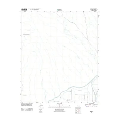
2012 Map of Araz
USGS Topo · Published 2012About this map
The Cargo Muchacho Mountains dominate the northwestern horizon of this arid landscape, where the seasonal drainage of Araz Wash, Picacho Wash, and Bee Wash cuts through the desert floor. In the south, the intricate plumbing of the California desert is on display, anchored by the massive All American Canal and the Pilot Knob Substation. The small settlement of Araz sits near the canal, surrounded by a complex network of irrigation laterals like the Tenino Lateral, Tonto Lateral, and Concow Lateral. These man-made watercourses, including the Yuma Main Canal and Reservation Main Drain, illustrate the transformation of this dry borderland into an engineered agricultural environment. Notable transport routes like Barney Oldfield Rd and Picacho Rd provide access through the open terrain, connecting the mountains to the managed waterways of the Imperial Valley.
Find a feature on this map
30 named features on this map. Tap any name to fly to it.
Don’t see what you’re looking for? This feature index may not catch every label — zoom into the map to look around manually.
Map Details
Editions of this 2012 Araz Map
This is the sole edition of this map. No revisions or reprints were ever made.
Other maps of this area

1903 · Yuma
USGS Topo · 1:125,000

1905 · Yuma
USGS Topo · 1:125,000

1940 · Yuma
USGS Topo · 1:62,500

1942 · Yuma
USGS Topo · 1:250,000

1945 · Picacho Peak
USGS Topo · 1:62,500

1945 · Yuma
USGS Topo · 1:62,500

1951 · Picacho Peak
USGS Topo · 1:62,500

1952 · Araz
USGS Topo · 1:24,000

1952 · Yuma East
USGS Topo · 1:24,000

1952 · Yuma West
USGS Topo · 1:24,000