
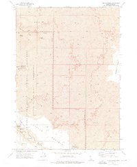
1972 Map of Arco South
USGS Topo · Published 1976About this map
The settlement of Arco sits at the junction of rail and river in this early 1970s survey. The Union Pacific line cuts through the northeastern corner, supporting local industry and the Arco Municipal Airport. The landscape is defined by the sharp contrast between the irrigated agricultural activity near the Big Lost River and the massive fields of Lava that dominate the southern and western portions of the quadrangle. Water management is central to the area's geography, visible through features like the Ferris Slough, a Siphon, and Canal systems that divert the river's flow for local use. To the south, the terrain rises toward Sixmile Butte, while the isolated Huddles Hole Road snakes through the volcanic flats, marking one of the few ways into the barren southern reaches.
Find a feature on this map
19 named features on this map. Tap any name to fly to it.
Don’t see what you’re looking for? This feature index may not catch every label — zoom into the map to look around manually.
Map Details
Editions of this 1972 Arco South Map
This is the sole edition of this map. No revisions or reprints were ever made.
Other maps of this area

1955 · Idaho Falls
USGS Topo · 1:250,000

1958 · Idaho Falls
USGS Topo · 1:250,000

1972 · Quaking Aspen Butte
USGS Topo · 1:24,000

1972 · Arco North
USGS Topo · 1:24,000

1972 · Butte City
USGS Topo · 1:24,000

1972 · Nichols Reservoir
USGS Topo · 1:24,000

1972 · Arco Hills
USGS Topo · 1:24,000

1972 · Fingers Butte
USGS Topo · 1:24,000

1972 · Appendicitis Hill
USGS Topo · 1:24,000
1973 · The Watchman
USGS Topo · 1:24,000