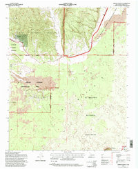
1995 Map of Arrosa Ranch
USGS Topo · Published 1998About this map
Arrosa Ranch and Porter Ranch anchor this high-desert landscape in west-central New Mexico, where cattle ranching meets the dramatic geological formations of the Lava flows. The area is defined by its complex jurisdictional boundaries, showing the convergence of the Cibola National Forest, El Malpais National Monument, and the El Malpais National Conservation Area. The terrain transitions from the elevations of Cerritos de Jaspe and Bonita Canyon in the north to the distinctive volcanic topography of the Little Hole in the Wall. Cultural history is traced along the Zuni Acoma Trail, which traverses the eastern side of the quadrangle. Early resource extraction is evidenced by scattered mines, prospects, and a Gravel Pit, providing a detailed look at the land use patterns prior to the mid-1990s.
Find a feature on this map
22 named features on this map. Tap any name to fly to it.
Don’t see what you’re looking for? This feature index may not catch every label — zoom into the map to look around manually.
Map Details
Editions of this 1995 Arrosa Ranch Map
This is the sole edition of this map. No revisions or reprints were ever made.
Other maps of this area

1883 · Mt. Taylor
USGS Topo · 1:250,000

1886 · Wingate
USGS Topo · 1:250,000

1886 · Mt. Taylor
USGS Topo · 1:250,000

1892 · Wingate
USGS Topo · 1:250,000

1892 · Mt. Taylor
USGS Topo · 1:250,000

1899 · Mt. Taylor
USGS Topo · 1:250,000

1917 · Broom Mountain
USGS Topo · 1:125,000

1952 · Paxton Springs
USGS Topo · 1:24,000

1954 · Saint Johns
USGS Topo · 1:250,000

1954 · Socorro
USGS Topo · 1:250,000