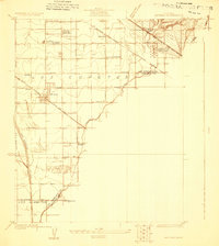
1923 Map of Artesia
USGS Topo · Published 1923About this map
The agricultural landscape of Los Coyotes is captured here during a pivotal era of industrial expansion, as the San Gabriel River and Coyote Creek define the low-lying plains. The settlement of Artesia serves as a central hub, surrounded by a grid of rural roads like Anaheim Street and Bloomfield Avenue. This 1923 survey reveals a transition from farming to the petroleum economy, highlighted by the presence of the C Julian Tank Farm and the Standard Oil Co Pumping Station.
Find a feature on this map
29 named features on this map. Tap any name to fly to it.
Don’t see what you’re looking for? This feature index may not catch every label — zoom into the map to look around manually.
Map Details
Editions of this 1923 Artesia Map
This is the sole edition of this map. No revisions or reprints were ever made.
Other maps of this area

1896 · Anaheim
USGS Topo · 1:62,500

1896 · Downey
USGS Topo · 1:62,500

1898 · Anaheim
USGS Topo · 1:62,500

1899 · Downey
USGS Topo · 1:62,500

1901 · Southern California Sheet No. 1
USGS Topo · 1:250,000

1901 · Anaheim
USGS Topo · 1:62,500

1902 · Downey
USGS Topo · 1:62,500

1902 · Corona
USGS Topo · 1:125,000

1904 · Southern California Sheet No. 1
USGS Topo · 1:250,000
1923 · Bell
USGS Topo · 1:24,000