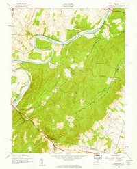
1943 Map of Ashby Gap
USGS Topo · Published 1961About this map
The Shenandoah River snakes through the northern landscape of this 1943 survey, carving a path around Burwell Island and Calameas Neck. This era of the Blue Ridge is defined by its transition from the valley floor to the high elevations of Ashby Gap, where Clarke, Loudoun, and Fauquier counties meet. The mountain crest is dominated by Mt Weather and the winding path of the Appalachian Trail, which follows the ridgeline southward. Local life is anchored in small settlements like Millwood and Pigeon Hill, supported by a network of rural education and worship sites including Mt Carmel Ch and Valley View Sch. The presence of the Norfolk & Western railroad in the northwest corner highlights the vital transport link that connected these agricultural and mountain communities to the broader Virginia region during the early 1940s.
Find a feature on this map
30 named features on this map. Tap any name to fly to it.
Don’t see what you’re looking for? This feature index may not catch every label — zoom into the map to look around manually.
Map Details
Editions of this 1943 Ashby Gap Map
This is the sole edition of this map. No revisions or reprints were ever made.
Other maps of this area

1884 · Harpers Ferry
USGS Topo · 1:125,000

1891 · Harpers Ferry
USGS Topo · 1:125,000

1893 · Luray
USGS Topo · 1:125,000

1893 · Harpers Ferry
USGS Topo · 1:125,000

1894 · Warrenton
USGS Topo · 1:125,000

1894 · Winchester
USGS Topo · 1:125,000

1905 · Luray
USGS Topo · 1:125,000

1916 · Berryville
USGS Topo · 1:62,500

1938 · Winchester
USGS Topo · 1:48,000

1939 · Front Royal
USGS Topo · 1:48,000