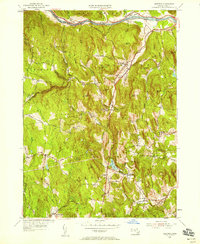
1955 Map of Ashfield
USGS Topo · Published 1958About this map
Ashfield and Buckland occupy the center of this 1955 survey of the Massachusetts highlands, where the Boston and Maine railroad tracks follow the winding course of the Deerfield River along the northern border. The landscape is defined by a dense network of hills and brook valleys, including named peaks like Mary Lyon Hill and Drake Hill. These topographic features dictated the early settlement patterns and road networks that connect rural outposts like Spruce Corner, Baptist Corner, and Dodge Corner.
Find a feature on this map
67 named features on this map. Tap any name to fly to it.
Don’t see what you’re looking for? This feature index may not catch every label — zoom into the map to look around manually.
Map Details
Editions of this 1955 Ashfield Map
3 editions found
Other maps of this area

1885 · Northampton
USGS Topo · 1:62,500

1886 · Hawley
USGS Topo · 1:62,500

1886 · Chesterfield
USGS Topo · 1:62,500

1886 · Northampton
USGS Topo · 1:62,500

1888 · Chesterfield
USGS Topo · 1:62,500

1890 · Hawley
USGS Topo · 1:62,500

1890 · Greenfield
USGS Topo · 1:62,500

1891 · Northampton
USGS Topo · 1:62,500

1893 · Northampton
USGS Topo · 1:62,500

1893 · Chesterfield
USGS Topo · 1:62,500