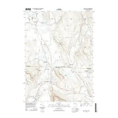
2015 Map of Ashley Falls
USGS Topo · Published 2015About this map
The Housatonic River and Konkapot River define the agricultural and wooded landscape across the Massachusetts-Connecticut border. This 2015 update documents the historical corridor from Sheffield to Canaan, where the valley floor transitions into the heights of Canaan Mtn and Miles Mtn. Traces of the region's heritage are visible in the Old Covered Bridge and several historical burial grounds including Center Cem and Barnard Cem. The map illustrates the contemporary infrastructure of the southern Berkshires and Litchfield Hills, from the North Canaan Aviation Facilities Inc Airport to the industrial legacy suggested by Ironwork Brook. The terrain is characterized by named hollows and hills like Smith Hollow and Benton Hill, which have long shaped the settlement patterns of villages like Ashley Falls and East Canaan.
Find a feature on this map
147 named features on this map. Tap any name to fly to it.
Don’t see what you’re looking for? This feature index may not catch every label — zoom into the map to look around manually.
Map Details
Editions of this 2015 Ashley Falls Map
This is the sole edition of this map. No revisions or reprints were ever made.
Other maps of this area

1885 · Sheffield
USGS Topo · 1:62,500

1888 · Sheffield
USGS Topo · 1:62,500

1888 · Sandisfield
USGS Topo · 1:62,500

1891 · Sheffield
USGS Topo · 1:62,500

1892 · Winsted
USGS Topo · 1:62,500

1892 · Cornwall
USGS Topo · 1:62,500

1893 · Sheffield
USGS Topo · 1:62,500

1893 · Cornwall
USGS Topo · 1:62,500

1893 · Sandisfield
USGS Topo · 1:62,500

1897 · Sandisfield
USGS Topo · 1:62,500