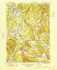
1949 Map of Ashley Falls
USGS Topo · Published 1949About this map
The Housatonic River snakes through the borderlands of Massachusetts and Connecticut, defining the agricultural and industrial character of this Berkshire County corridor. In the years following World War II, the landscape remained deeply rooted in its early settlement patterns, with the river powering mills and the New Haven and Hartford Road serving as a vital artery for the region. The map reveals a dense concentration of family history markers, particularly around Sheffield and the village of Ashley Falls, where established landmarks like Center Cem and Hewins Cem speak to generations of residency.
Find a feature on this map
57 named features on this map. Tap any name to fly to it.
Don’t see what you’re looking for? This feature index may not catch every label — zoom into the map to look around manually.
Map Details
Editions of this 1949 Ashley Falls Map
2 editions found
Other maps of this area

1885 · Sheffield
USGS Topo · 1:62,500

1888 · Sheffield
USGS Topo · 1:62,500

1888 · Sandisfield
USGS Topo · 1:62,500

1891 · Sheffield
USGS Topo · 1:62,500

1892 · Winsted
USGS Topo · 1:62,500

1892 · Cornwall
USGS Topo · 1:62,500

1893 · Sheffield
USGS Topo · 1:62,500

1893 · Cornwall
USGS Topo · 1:62,500

1893 · Sandisfield
USGS Topo · 1:62,500

1897 · Sandisfield
USGS Topo · 1:62,500