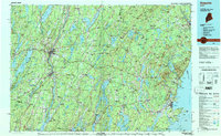
1984 Map of Augusta
USGS Topo · Published 1984About this map
The Kennebec River corridor anchors this mid-1980s landscape, flowing through the state capital of Augusta and south past the river towns of Hallowell and Gardiner. This region is defined by its deep connectivity between the interior lake districts and the rocky mid-coast. The transportation network of US Highway 201 and the Maine Central RR follows the river's path, while to the east, the coastal heights of the Camden Hills rise sharply from the sea.
Find a feature on this map
207 named features on this map. Tap any name to fly to it.
Don’t see what you’re looking for? This feature index may not catch every label — zoom into the map to look around manually.
Map Details
Editions of this 1984 Augusta Map
This is the sole edition of this map. No revisions or reprints were ever made.
Other maps of this area
1892 · Gardiner
USGS Topo · 1:62,500
1892 · Freeport
USGS Topo · 1:62,500
1892 · Waterville
USGS Topo · 1:62,500

1892 · Augusta
USGS Topo · 1:62,500
1893 · Vassalboro
USGS Topo · 1:62,500
1893 · Wiscasset
USGS Topo · 1:62,500
1893 · Boothbay
USGS Topo · 1:62,500

1894 · Norridgewock
USGS Topo · 1:62,500
1894 · Bath
USGS Topo · 1:62,500

1898 · Norridgewock
USGS Topo · 1:62,500