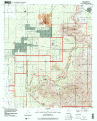
1996 Map of Avra
USGS Topo · Published 2001About this map
The Avra Valley provides a sharp contrast between the irrigated agricultural lowlands and the protected desert peaks of the Saguaro National Park (Tucson Mountain Section). The settlement of Avra sits amidst a network of flumes and an aqueduct, supporting the region's intensive water management needs. To the east, the landscape rises toward high points like Wasson Peak and Panther Peak, where mining history is preserved at the Gould Mine, Mile-Wide Mine, and a notable Gold Mine. This mid-1990s record documents the established recreational infrastructure of the Saguaro Wilderness, including the Red Hills Visitor Center and various public gathering spots such as the Signal Hill Picnic Area and Cam-Boh Picnic Area. The map also captures industrial activity at a large Quarry near Twin Peaks, illustrating the balance of preservation and extraction in the Tucson vicinity.
Find a feature on this map
63 named features on this map. Tap any name to fly to it.
Don’t see what you’re looking for? This feature index may not catch every label — zoom into the map to look around manually.
Map Details
Editions of this 1996 Avra Map
This is the sole edition of this map. No revisions or reprints were ever made.
Other maps of this area

1925 · San Xavier
USGS Topo · 1:62,500

1934 · Tucson Mountains
USGS Topo · 1:125,000

1941 · Cocoraque Butte
USGS Topo · 1:62,500

1943 · Cocoraque Butte
USGS Topo · 1:62,500

1943 · San Xavier Mission
USGS Topo · 1:62,500

1947 · Cortaro
USGS Topo · 1:62,500

1956 · Tucson
USGS Topo · 1:250,000

1957 · San Xavier Mission
USGS Topo · 1:62,500

1957 · Cortaro
USGS Topo · 1:62,500

1958 · Tucson
USGS Topo · 1:250,000