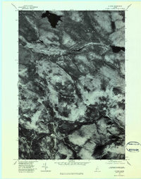
1977 Map of B Pond
USGS Topo · Published 1984About this map
B Pond and the high-elevation terrain of Oxford County define this 1977 orthophotoquad, which uses rectified aerial imagery to document a landscape shaped by water and timber. The map is centered on the distinctively dark, clear waters of B Pond and C Pond, revealing the complex drainage patterns of the western Maine woods. The hydrology of the region is notably represented by the sluggish reaches of the Dead Cambridge River and its swifter counterpart, the Swift Cambridge River, providing a clear visual contrast in how water moves through this part of the Mahoosuc Range. Beyond the water, the imagery captures the dense forest cover surrounding Surplus Mountain, where the lack of development highlights the area's use as managed woodland. Local researchers can trace the course of the West Branch Ellis River and Greenwood Brook through the shadows and textures of the timberland as it stood in the late 1970s.
Find a feature on this map
7 named features on this map. Tap any name to fly to it.
Don’t see what you’re looking for? This feature index may not catch every label — zoom into the map to look around manually.
Map Details
Editions of this 1977 B Pond Map
2 editions found
Other maps of this area

1930 · Milan
USGS Topo · 1:62,500

1930 · Errol
USGS Topo · 1:62,500

1933 · Milan
USGS Topo · 1:62,500

1934 · Errol
USGS Topo · 1:62,500

1934 · Milan
USGS Topo · 1:62,500

1940 · Oquossoc
USGS Topo · 1:62,500

1942 · Oquossoc
USGS Topo · 1:62,500

1943 · Old Speck Mtn
USGS Topo · 1:62,500

1945 · Old Speck Mtn
USGS Topo · 1:62,500

1950 · Lewiston
USGS Topo · 1:250,000
Featured Places
- Upton, ME
- Grafton Township, ME
- Andover North Surplus Township, ME
- Andover West Surplus Township, ME
- Township C, ME