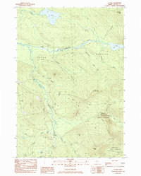
1984 Map of B Pond
USGS Topo · Published 1985About this map
Dead River and Cambridge River converge in this high-elevation Oxford County landscape, which remains largely dominated by timber tracts and township divisions like Andover North Surplus and Grafton (TA 2). The mid-1980s terrain is characterized by its complex hydrology, with waters flowing through B Pond and C Pond toward the larger river systems. Historically, this area has been defined by its geography rather than dense settlement, though a small Cem and a Sand and Gravel Pit near the Swift River indicate localized human activity and land use.
Find a feature on this map
41 named features on this map. Tap any name to fly to it.
Don’t see what you’re looking for? This feature index may not catch every label — zoom into the map to look around manually.
Map Details
Editions of this 1984 B Pond Map
This is the sole edition of this map. No revisions or reprints were ever made.
Other maps of this area

1930 · Milan
USGS Topo · 1:62,500

1930 · Errol
USGS Topo · 1:62,500

1933 · Milan
USGS Topo · 1:62,500

1934 · Errol
USGS Topo · 1:62,500

1934 · Milan
USGS Topo · 1:62,500

1940 · Oquossoc
USGS Topo · 1:62,500

1942 · Oquossoc
USGS Topo · 1:62,500

1943 · Old Speck Mtn
USGS Topo · 1:62,500

1945 · Old Speck Mtn
USGS Topo · 1:62,500

1950 · Lewiston
USGS Topo · 1:250,000
Featured Places
- Upton, ME
- Grafton Township, ME
- Andover North Surplus Township, ME
- Andover West Surplus Township, ME
- Township C, ME