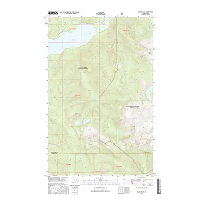
2017 Map of Bacon Peak
USGS Topo · Published 2017About this map
Bacon Peak and the high elevations of the North Cascades National Park dominate this 2017 survey at the boundary of Whatcom County and Skagit County. The northern reaches of the map are defined by the expansive Baker Lake, where the Baker River enters from the north near the Pacific NW National Scenic Trail. This long-distance path traverses the high country, passing through the Mount Baker National Forest and skirting the slopes above Shuksan Cr. The landscape is dotted with numerous high-altitude water bodies, including Watson Lakes, Anderson Lakes, Edgar Lake, and the remote Ipsut Lake. Geological and topographical points of interest such as Anderson Butte and Mt Watson provide significant landmarks for those studying the physical geography and trail networks of the western Cascades during this modern era of federal land management.
Find a feature on this map
39 named features on this map. Tap any name to fly to it.
Don’t see what you’re looking for? This feature index may not catch every label — zoom into the map to look around manually.
Map Details
Editions of this 2017 Bacon Peak Map
This is the sole edition of this map. No revisions or reprints were ever made.
Other maps of this area

1909 · Mt Baker
USGS Topo · 1:192,000

1915 · Mt. Baker
USGS Topo · 1:250,000

1952 · Lake Shannon
USGS Topo · 1:62,500

1953 · Mt Shuksan
USGS Topo · 1:62,500

1953 · Marblemount
USGS Topo · 1:62,500

1953 · Mt Challenger
USGS Topo · 1:62,500

1955 · Concrete
USGS Topo · 1:250,000

1958 · Concrete
USGS Topo · 1:250,000

1962 · Concrete
USGS Topo · 1:250,000

1979 · Mt. Baker
USGS Topo · 1:100,000