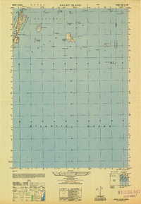
1950 Map of Bailey Island
USGS Topo · Published 1950About this map
Bailey Island dominates this maritime survey, showing the finger-like projection into Casco Bay before mid-century modernization. The map documents the intricate coastal topography of Harpswell, where narrow channels like Wills Strait and Jaquish Gut separate landmasses. The settlement on the main island is anchored by a Windmill and various landmarks such as David Castle.
Find a feature on this map
38 named features on this map. Tap any name to fly to it.
Don’t see what you’re looking for? This feature index may not catch every label — zoom into the map to look around manually.
Map Details
Editions of this 1950 Bailey Island Map
This is the sole edition of this map. No revisions or reprints were ever made.
Other maps of this area

1892 · Freeport
USGS Topo · 1:62,500

1893 · Small Point
USGS Topo · 1:62,500

1893 · Casco Bay
USGS Topo · 1:62,500

1894 · Bath
USGS Topo · 1:62,500

1914 · Casco Bay
USGS Topo · 1:48,000

1916 · Casco Bay
USGS Topo · 1:62,500

1916 · Portland And Vicinity
USGS Topo · 1:62,500

1918 · Portland And Vicinity
USGS Topo · 1:62,500

1919 · Small Point
USGS Topo · 1:62,500

1920 · Bath
USGS Topo · 1:62,500