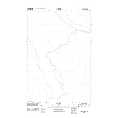
2011 Map of Baker Lake NW
USGS Topo · Published 2011About this map
The Southwest Branch Saint John River and the Baker Branch Saint John River converge in this remote corner of Somerset County, highlighting a landscape defined by the upper reaches of the Saint John drainage. At the time of this 2011 survey, the area remains primarily wild, with the only significant man-made infrastructure being the Carter Nine Mile Rd, which skirts the western edge of the terrain. The map documents the intricate river hydrology, showing the numerous small islands and complex branching of the waterways as they move through the township of T9 R17 WELS. This representation is vital for understanding the untouched state of the North Maine Woods, where topography and hydrology remain the dominant features over human settlement.
Find a feature on this map
3 named features on this map. Tap any name to fly to it.
Don’t see what you’re looking for? This feature index may not catch every label — zoom into the map to look around manually.
Map Details
Editions of this 2011 Baker Lake NW Map
This is the sole edition of this map. No revisions or reprints were ever made.
Other maps of this area

1954 · Baker Lake
USGS Topo · 1:62,500

1954 · Presque Isle
USGS Topo · 1:250,000

1955 · Beaver Pond
USGS Topo · 1:62,500

1957 · Hardwood Mountain
USGS Topo · 1:62,500

1958 · Presque Isle
USGS Topo · 1:250,000

1960 · Presque Isle
USGS Topo · 1:250,000

1962 · Baker Lake
USGS Topo · 1:62,500

1962 · Quebec
USGS Topo · 1:250,000
1986 · Beaver Pond SE
USGS Topo · 1:24,000
1986 · Chamberlain Lake
USGS Topo · 1:100,000