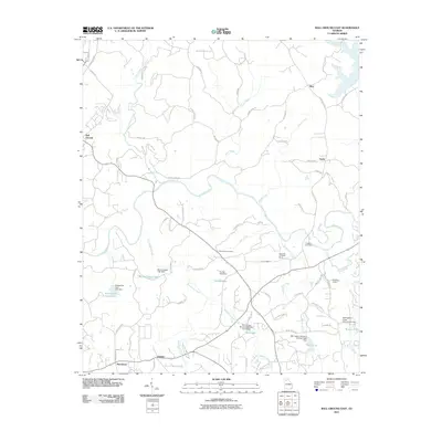
2011 Map of Ball Ground East
USGS Topo · Published 2011About this map
Mining history and water management define the landscape of eastern Cherokee County, where the Etowah River carves through the central portion of the quadrangle. Significant industrial heritage is recorded at the Franklin Gold Mine and the Standard and Swift Mines, while the Cherokee Quarry further south indicates the diverse geological activity of the region. Small communities such as Mica, Ophir, Orange, and Macedonia are connected by a network of rural roads, including those with evocative names like Trail of Tears Trl and Prospector Way. Local genealogy is anchored at the Cane Creek Cemetery, situated near the confluence of Cane Creek and the river. Numerous small reservoirs and structures, such as Tustian Lake, Bartholomew Lake, and Ball Lake, suggest a heavily managed watershed, with specific infrastructure like the Mill Canton Structure Number Three Dam and Settingdown Creek Structure 27 Dam providing precise data for property researchers.
Find a feature on this map
79 named features on this map. Tap any name to fly to it.
Don’t see what you’re looking for? This feature index may not catch every label — zoom into the map to look around manually.
Map Details
Editions of this 2011 Ball Ground East Map
This is the sole edition of this map. No revisions or reprints were ever made.
Other maps of this area

1890 · Suwanee
USGS Topo · 1:125,000

1894 · Suwanee
USGS Topo · 1:125,000

1926 · Tate
USGS Topo · 1:62,500

1928 · Tate
USGS Topo · 1:62,500

1955 · Rome
USGS Topo · 1:250,000

1956 · Birmingham
USGS Topo · 1:24,000

1958 · Rome
USGS Topo · 1:250,000

1961 · Rome
USGS Topo · 1:250,000
1961 · Canton
USGS Topo · 1:24,000

1963 · Rome
USGS Topo · 1:250,000