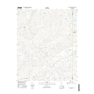
2017 Map of Ball Ground East
USGS Topo · Published 2017About this map
The Etowah River carves a central path through this portion of Cherokee County, where the foothills topography is defined by the confluence of numerous watercourses like Long Swamp Creek and Smithwick Cr. Small rural settlements such as Mica, Ophir, and Orange are connected by a network of winding roads, including the historically significant Old Federal Rd and a segment of the Trl Of Tears near the Dawson County line. This map reveals a landscape balancing localized development with preserved natural drainage, as seen in the cluster of private reservoirs like Bartholomew Lake and Atlanta Gas Light Lake. Genealogists may find value in the location of the Cane Creek Cem, situated near the rural crossroads of Macedonia and the southeastern outskirts of Ball Ground.
Find a feature on this map
109 named features on this map. Tap any name to fly to it.
Don’t see what you’re looking for? This feature index may not catch every label — zoom into the map to look around manually.
Map Details
Editions of this 2017 Ball Ground East Map
This is the sole edition of this map. No revisions or reprints were ever made.
Other maps of this area

1890 · Suwanee
USGS Topo · 1:125,000

1894 · Suwanee
USGS Topo · 1:125,000

1926 · Tate
USGS Topo · 1:62,500

1928 · Tate
USGS Topo · 1:62,500

1955 · Rome
USGS Topo · 1:250,000

1956 · Birmingham
USGS Topo · 1:24,000

1958 · Rome
USGS Topo · 1:250,000

1961 · Rome
USGS Topo · 1:250,000
1961 · Canton
USGS Topo · 1:24,000

1963 · Rome
USGS Topo · 1:250,000