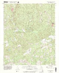
1993 Map of Ball Ground East
USGS Topo · Published 1999About this map
The Etowah River carves a winding path through this corner of Cherokee County, defining a landscape where rural settlements and forest management dominate. Much of the riverfront is protected by the McGraw Ford State Wildlife Mgmt Area, which spans several sharp meanders of the waterway. Outside the conservation lands, a network of country roads connects historic community centers like Mica, Orange, and Ophir. The map reveals a high density of rural religious life, with Mica Ch, Cherry Grove Ch, and Shiloh Ch serving as anchors for local families. In the southern reaches, the transition toward more developed areas is visible near Macedonia and White City, though the winding courses of Seetingdown Creek and Long Swamp Creek continue to dictate the local topography.
Find a feature on this map
35 named features on this map. Tap any name to fly to it.
Don’t see what you’re looking for? This feature index may not catch every label — zoom into the map to look around manually.
Map Details
Editions of this 1993 Ball Ground East Map
This is the sole edition of this map. No revisions or reprints were ever made.
Other maps of this area

1890 · Suwanee
USGS Topo · 1:125,000

1894 · Suwanee
USGS Topo · 1:125,000

1926 · Tate
USGS Topo · 1:62,500

1928 · Tate
USGS Topo · 1:62,500

1955 · Rome
USGS Topo · 1:250,000

1956 · Birmingham
USGS Topo · 1:24,000

1958 · Rome
USGS Topo · 1:250,000

1961 · Rome
USGS Topo · 1:250,000
1961 · Canton
USGS Topo · 1:24,000

1963 · Rome
USGS Topo · 1:250,000