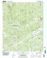
1999 Map of Ball Ground East
USGS Topo · Published 2003About this map
The Etowah River carves a serpentine path through the center of this Cherokee County landscape, defining the topography south of Ball Ground. The terrain is characterized by a dense network of watercourses, including Long Swamp Creek and Cane Creek, which feed into the primary river valley. Much of the central acreage is dedicated to the McGraw Ford State Wildlife Mgmt Area, preserving the riparian environment where the river bends sharply eastward.
Find a feature on this map
35 named features on this map. Tap any name to fly to it.
Don’t see what you’re looking for? This feature index may not catch every label — zoom into the map to look around manually.
Map Details
Editions of this 1999 Ball Ground East Map
This is the sole edition of this map. No revisions or reprints were ever made.
Other maps of this area

1890 · Suwanee
USGS Topo · 1:125,000

1894 · Suwanee
USGS Topo · 1:125,000

1926 · Tate
USGS Topo · 1:62,500

1928 · Tate
USGS Topo · 1:62,500

1955 · Rome
USGS Topo · 1:250,000

1956 · Birmingham
USGS Topo · 1:24,000

1958 · Rome
USGS Topo · 1:250,000

1961 · Rome
USGS Topo · 1:250,000
1961 · Canton
USGS Topo · 1:24,000

1963 · Rome
USGS Topo · 1:250,000