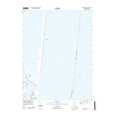
2014 Map of Barnegat Light
USGS Topo · Published 2014About this map
Barnegat Light sits at the northern tip of Long Beach Island, marking the critical threshold between Barnegat Bay and the Atlantic Ocean. This 2014 survey details the intricate shoreline of the Barnegat Inlet, where coastal engineering like The Dike protects the navigable channel. To the north, the slender ribbon of Island Beach remains largely undeveloped, contrasted by the grid of streets in the borough including Central Ave and Broadway. The map reveals the shifting nature of the Jersey Shore's maritime environment, from the protected waters of Johnny Allens Cove to the clusters of the Sedge Islands. This geography underscores the tension between the dense seasonal settlements of Long Beach and the fragile, migrating sands of the barrier island system.
Find a feature on this map
17 named features on this map. Tap any name to fly to it.
Don’t see what you’re looking for? This feature index may not catch every label — zoom into the map to look around manually.
Map Details
Editions of this 2014 Barnegat Light Map
This is the sole edition of this map. No revisions or reprints were ever made.
Other maps of this area

1888 · Barnegat
USGS Topo · 1:62,500

1888 · Long Beach
USGS Topo · 1:62,500

1893 · Long Beach
USGS Topo · 1:62,500

1893 · Barnegat
USGS Topo · 1:62,500

1898 · Barnegat
USGS Topo · 1:62,500

1919 · Long Beach
USGS Topo · 1:62,500

1919 · Barnegat
USGS Topo · 1:62,500

1941 · Toms River
USGS Topo · 1:62,500
1941 · Long Beach
USGS Topo · 1:62,500

1946 · Wilmington
USGS Topo · 1:250,000