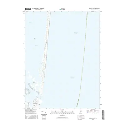
2016 Map of Barnegat Light
USGS Topo · Published 2016About this map
Barnegat Light stands at the southern terminus of this survey, marking the crucial transition between the open Atlantic Ocean and the sheltered waters of Barnegat Bay. The map highlights the dynamic coastal geography of the Jersey Shore, where the narrow barrier of Island Beach stretches southward toward the complex shoals and channels of Barnegat Inlet. This maritime landscape is defined by the shifting sands of the Sedge Islands and the protective structure of The Dike, which help manage the volatile water flow near the inlet.
Find a feature on this map
17 named features on this map. Tap any name to fly to it.
Don’t see what you’re looking for? This feature index may not catch every label — zoom into the map to look around manually.
Map Details
Editions of this 2016 Barnegat Light Map
This is the sole edition of this map. No revisions or reprints were ever made.
Other maps of this area

1888 · Barnegat
USGS Topo · 1:62,500

1888 · Long Beach
USGS Topo · 1:62,500

1893 · Long Beach
USGS Topo · 1:62,500

1893 · Barnegat
USGS Topo · 1:62,500

1898 · Barnegat
USGS Topo · 1:62,500

1919 · Long Beach
USGS Topo · 1:62,500

1919 · Barnegat
USGS Topo · 1:62,500

1941 · Toms River
USGS Topo · 1:62,500
1941 · Long Beach
USGS Topo · 1:62,500

1946 · Wilmington
USGS Topo · 1:250,000