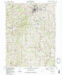
1994 Map of Barnesville
USGS Topo · Published 1998About this map
Barnesville serves as the primary hub of activity in this Belmont County landscape, characterized by its concentrated industrial and civic infrastructure. The town is flanked by multiple religious and educational sites, including the Olney Sch and the historic Chestnut Ridge Meetinghouse. To the north, the County Childrens Home at Tacoma and the Memorial Park highlight the social development of the era.
Find a feature on this map
55 named features on this map. Tap any name to fly to it.
Don’t see what you’re looking for? This feature index may not catch every label — zoom into the map to look around manually.
Map Details
Editions of this 1994 Barnesville Map
This is the sole edition of this map. No revisions or reprints were ever made.
Other maps of this area

1903 · Flushing
USGS Topo · 1:62,500

1905 · Woodsfield
USGS Topo · 1:62,500

1905 · Flushing
USGS Topo · 1:62,500

1909 · Antrim
USGS Topo · 1:48,000

1909 · Summerfield
USGS Topo · 1:62,500

1911 · Antrim
USGS Topo · 1:62,500

1911 · Summerfield
USGS Topo · 1:62,500

1949 · Clarksburg
USGS Topo · 1:250,000

1951 · Canton
USGS Topo · 1:250,000

1953 · Canton
USGS Topo · 1:250,000