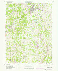
1961 Map of Barnesville
USGS Topo · Published 1976About this map
Barnesville serves as the primary hub of this eastern Ohio landscape, where the ridge-and-valley topography of Warren and Somerset townships is defined by intensive resource extraction and established Quaker heritage. Numerous Strip Mine operations and gas wells pockmark the hillsides of Shannon Run and Leatherwood Creek, illustrating the region's industrial reliance on coal and natural gas during the mid-20th century. The cultural footprint of the Society of Friends is remarkably preserved through labels for the Friends Sch, Olney Sch, and the Old Quaker Cem near Somerton. Transportation corridors like the Baltimore and Ohio railroad wind through the valleys, connecting smaller settlements like Baileys Mills and Tacoma. Local infrastructure is well-documented, including the County Childrens Home, the Howell Airport, and the Drive-in Theater situated along the highway west of the main town center.
Find a feature on this map
58 named features on this map. Tap any name to fly to it.
Don’t see what you’re looking for? This feature index may not catch every label — zoom into the map to look around manually.
Map Details
Editions of this 1961 Barnesville Map
Other maps of this area

1903 · Flushing
USGS Topo · 1:62,500

1905 · Woodsfield
USGS Topo · 1:62,500

1905 · Flushing
USGS Topo · 1:62,500

1909 · Antrim
USGS Topo · 1:48,000

1909 · Summerfield
USGS Topo · 1:62,500

1911 · Antrim
USGS Topo · 1:62,500

1911 · Summerfield
USGS Topo · 1:62,500

1949 · Clarksburg
USGS Topo · 1:250,000

1951 · Canton
USGS Topo · 1:250,000

1953 · Canton
USGS Topo · 1:250,000