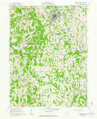
1961 Map of Barnesville
USGS Topo · Published 1963About this map
Barnesville serves as the bustling focal point of this Belmont County survey, appearing as a hub of civic life with its Hospital, Memorial Park, and the County Childrens Home. The town’s industrial and educational roots are clear, from the Baltimore and Ohio railroad cutting through the terrain to the presence of the Friends Sch and Olney Sch. Outside the village center, the landscape is deeply etched by coal and gas extraction, with numerous Strip Mines and Gas Wells dotting the ridges between Shannon Run and Leatherwood Creek.
Find a feature on this map
49 named features on this map. Tap any name to fly to it.
Don’t see what you’re looking for? This feature index may not catch every label — zoom into the map to look around manually.
Map Details
Editions of this 1961 Barnesville Map
Other maps of this area

1903 · Flushing
USGS Topo · 1:62,500

1905 · Woodsfield
USGS Topo · 1:62,500

1905 · Flushing
USGS Topo · 1:62,500

1909 · Antrim
USGS Topo · 1:48,000

1909 · Summerfield
USGS Topo · 1:62,500

1911 · Antrim
USGS Topo · 1:62,500

1911 · Summerfield
USGS Topo · 1:62,500

1949 · Clarksburg
USGS Topo · 1:250,000

1951 · Canton
USGS Topo · 1:250,000

1953 · Canton
USGS Topo · 1:250,000