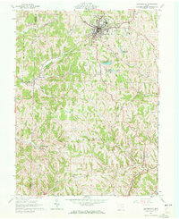
1961 Map of Barnesville
USGS Topo · Published 1972About this map
Barnesville serves as the primary hub of this eastern Ohio landscape, where the Baltimore And Ohio railroad cuts through the northern hills. The town is marked by local institutions including a Hospital, a County Childrens Home, and several educational sites like the Friends Sch and Olney Sch. Outside the main settlement, the terrain transitions into a series of ridges and hollows, such as Dog Hollow and Sandy Ridge, dotted with small hamlets and cemeteries that reflect the area's Quaker heritage and early settlement patterns.
Find a feature on this map
50 named features on this map. Tap any name to fly to it.
Don’t see what you’re looking for? This feature index may not catch every label — zoom into the map to look around manually.
Map Details
Editions of this 1961 Barnesville Map
Other maps of this area

1903 · Flushing
USGS Topo · 1:62,500

1905 · Woodsfield
USGS Topo · 1:62,500

1905 · Flushing
USGS Topo · 1:62,500

1909 · Antrim
USGS Topo · 1:48,000

1909 · Summerfield
USGS Topo · 1:62,500

1911 · Antrim
USGS Topo · 1:62,500

1911 · Summerfield
USGS Topo · 1:62,500

1949 · Clarksburg
USGS Topo · 1:250,000

1951 · Canton
USGS Topo · 1:250,000

1953 · Canton
USGS Topo · 1:250,000