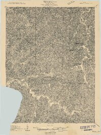
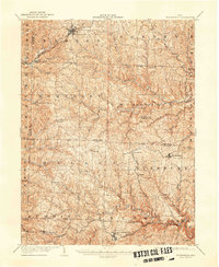
1909 Map of Antrim
USGS Topo · Published 1909About this map
Guernsey County and its neighbors in Harrison and Tuscarawas counties are defined by a complex network of ridgelines and stream valleys in this 1909 study. Small agricultural settlements such as Antrim, Londonderry, and Milnersville serve as central nodes for the surrounding rural townships of Madison, Oxford, and Freeport. The landscape is densely punctuated by civic landmarks essential to early 20th-century life, including local schools like Moccasin School, North Union School, and Grapevine School. Religious and community gatherings are centered around sites such as Allen Chapel and Pleasant Hill Church. The drainage pattern is led by the Stillwater and Salt Fork systems, which carved the deep hollows that dictated the placement of roads and farmsteads. This map reveals the intricate social and topographic grain of the region before the consolidation of rural schools and the modernization of the local road network.
Find a feature on this map
32 named features on this map. Tap any name to fly to it.
Don’t see what you’re looking for? This feature index may not catch every label — zoom into the map to look around manually.
Map Details
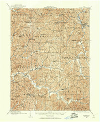
Editions of this 1909 Antrim Map
2 editions found
Other maps of this area
1902 · Scio
USGS Topo · 1:62,500

1903 · Flushing
USGS Topo · 1:62,500
1904 · Scio
USGS Topo · 1:62,500
1905 · Woodsfield
USGS Topo · 1:62,500

1905 · Flushing
USGS Topo · 1:62,500

1909 · Uhrichsville
USGS Topo · 1:62,500
1909 · Summerfield
USGS Topo · 1:62,500

1909 · Cambridge
USGS Topo · 1:62,500
1911 · Antrim
USGS Topo · 1:62,500

1911 · Uhrichsville
USGS Topo · 1:62,500