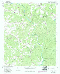
1964 Map of Barnett Shoals
USGS Topo · Published 1986About this map
Oconee River frontage and the industrial site at Barnett Shoals anchor this mid-1960s study of the Georgia piedmont. The landscape is defined by the convergence of several county boundaries, including Clarke, Oconee, Oglethorpe, and Greene. At the heart of the map, the Barnett Shoals Dam and adjacent Powerplant represent the area's hydroelectric development, while the surrounding hills are dotted with family cemeteries such as Veal Cem and Hardigree Cem. Rural infrastructure is prominent, featuring crossings like the Covered Bridge on Elder Road and the Wire Bridge further downstream. The southern portion of the sheet transitions into the protected woodlands of the Oconee National Forest, where small tributaries like Falling Creek and Barrow Creek drain toward the river. Scattered community life is centered around local congregations, including Oak Hill Ch and Antioch Ch.
Find a feature on this map
60 named features on this map. Tap any name to fly to it.
Don’t see what you’re looking for? This feature index may not catch every label — zoom into the map to look around manually.
Map Details
Editions of this 1964 Barnett Shoals Map
2 editions found
Other maps of this area

1953 · Athens
USGS Topo · 1:250,000

1958 · Athens
USGS Topo · 1:250,000

1959 · Athens
USGS Topo · 1:250,000

1963 · Athens
USGS Topo · 1:250,000

1964 · Athens West
USGS Topo · 1:24,000

1964 · Barnett Shoals
USGS Topo · 1:24,000

1964 · Watkinsville
USGS Topo · 1:24,000
1964 · Athens East
USGS Topo · 1:24,000
1971 · Crawford
USGS Topo · 1:24,000

1971 · Maxeys
USGS Topo · 1:24,000