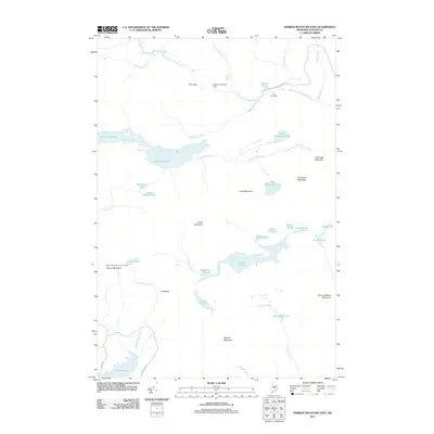
2011 Map of Barren Mountain East
USGS Topo · Published 2011About this map
The West Branch Pleasant River carves a dramatic path through this section of Piscataquis County, marked by a series of cascades including Stair Falls, Billings Falls, Buttermilk Falls, and Screw Auger Falls. This mountainous terrain is anchored by the ridge line of Barren Mountain, where the Barren Mountain Lookout Tower stands as a prominent landmark. To the south, the waters of Lake Onawa and Indian Pond provide a contrast to the high elevations of Fourth Mountain and Columbus Mountain. The Presence of The Hermitage and the historic route of Katahdin Iron Works Rd indicate the area's long-standing connection to early Maine industry and wilderness retreats. This landscape is further defined by its complex hydrology, featuring the Second Narrows of Long Pond and numerous smaller water bodies like Pugwash Pond and Sampson Pond.
Find a feature on this map
52 named features on this map. Tap any name to fly to it.
Don’t see what you’re looking for? This feature index may not catch every label — zoom into the map to look around manually.
Map Details
Editions of this 2011 Barren Mountain East Map
This is the sole edition of this map. No revisions or reprints were ever made.
Other maps of this area

1940 · Sebec
USGS Topo · 1:48,000

1943 · Sebec
USGS Topo · 1:62,500

1950 · Sebec Lake
USGS Topo · 1:62,500

1952 · Jo-Mary Mountain
USGS Topo · 1:62,500

1952 · First Roach Pond
USGS Topo · 1:62,500

1954 · Millinocket
USGS Topo · 1:250,000

1958 · Millinocket
USGS Topo · 1:250,000

1960 · Millinocket
USGS Topo · 1:250,000
1977 · Monson East
USGS Topo · 1:24,000
1977 · Number Four Mountain
USGS Topo · 1:24,000
Featured Places
- Bowerbank, ME
- Bowdoin College Grant East Township, ME
- Elliottsville Township, ME
- Bowdoin College Grant West Township, ME
- T7 R9 NWP, ME