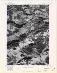
1978 Map of Barren Mountain East
USGS Topo · Published 1981About this map
Barren Mountain and the surrounding high peaks of Piscataquis County dominate this 1978 orthophotoquad, which uses aerial imagery to show the land exactly as it appeared. The terrain is defined by dramatic ridgelines and several significant water bodies, including Long Pond and Indian Pond, nestled between the slopes of Columbus Mountain and Fourth Mountain. The West Branch Pleasant River cuts through the northern portion of the landscape, while the southern edge features the northern reaches of Lake Onawa. This perspective emphasizes the raw geological forms and dense forest cover of the Maine woods, providing a clear record of the area's physical geography and undeveloped character during the late 1970s before any modern alterations.
Find a feature on this map
8 named features on this map. Tap any name to fly to it.
Don’t see what you’re looking for? This feature index may not catch every label — zoom into the map to look around manually.
Map Details
Editions of this 1978 Barren Mountain East Map
This is the sole edition of this map. No revisions or reprints were ever made.
Other maps of this area

1940 · Sebec
USGS Topo · 1:48,000

1943 · Sebec
USGS Topo · 1:62,500

1950 · Sebec Lake
USGS Topo · 1:62,500

1952 · Jo-Mary Mountain
USGS Topo · 1:62,500

1952 · First Roach Pond
USGS Topo · 1:62,500

1954 · Millinocket
USGS Topo · 1:250,000

1958 · Millinocket
USGS Topo · 1:250,000

1960 · Millinocket
USGS Topo · 1:250,000
1977 · Monson East
USGS Topo · 1:24,000
1977 · Number Four Mountain
USGS Topo · 1:24,000
Featured Places
- Bowerbank, ME
- Bowdoin College Grant West Township, ME
- T7 R9 NWP, ME
- Elliottsville Township, ME
- Bowdoin College Grant East Township, ME