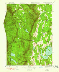
1948 Map of Bashbish Falls
USGS Topo · Published 1948About this map
The Tri-state border of Massachusetts, New York, and Connecticut converges at the summit of Mt Frissell in this 1948 edition, revealing a high-elevation landscape defined by significant topographic relief and recreation. The Appalachian Trail winds through the heart of the terrain, passing through Sages Ravine and over Bear Mtn toward the Mt Washington Fire Tower atop Mt Everett.
Find a feature on this map
62 named features on this map. Tap any name to fly to it.
Don’t see what you’re looking for? This feature index may not catch every label — zoom into the map to look around manually.
Map Details
Editions of this 1948 Bashbish Falls Map
This is the sole edition of this map. No revisions or reprints were ever made.
Other maps of this area

1885 · Sheffield
USGS Topo · 1:62,500

1888 · Sheffield
USGS Topo · 1:62,500

1891 · Sheffield
USGS Topo · 1:62,500

1892 · Cornwall
USGS Topo · 1:62,500

1893 · Sheffield
USGS Topo · 1:62,500

1893 · Cornwall
USGS Topo · 1:62,500

1897 · Sheffield
USGS Topo · 1:62,500

1899 · Housatonic
USGS Topo · 1:125,000

1899 · Millbrook
USGS Topo · 1:62,500

1900 · Housatonic
USGS Topo · 1:125,000