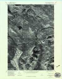
1977 Map of Basin Mountain
USGS Topo · Published 1983About this map
Basin Mountain and Hurricane Mountain dominate this Somerset County landscape, as captured in late October by high-altitude aerial photography. The terrain is defined by a dense drainage network where the meandering Dead River meets the winding path of Spencer Stream. This orthophotoquad provides a clear visual record of the forest canopy and hydrological patterns before the 1980s, highlighting remote water bodies like Alder Pond and the narrow descent of Stony Brook. The image reveals the sharp contrast between the dark, wooded slopes and the bright, reflective paths of the waterways, including the secluded Halfway Brook. This specific type of survey emphasizes the literal ground cover and timbered ridges over man-made structures, offering a precise look at the wilderness state of the region during the late seventies.
Find a feature on this map
7 named features on this map. Tap any name to fly to it.
Don’t see what you’re looking for? This feature index may not catch every label — zoom into the map to look around manually.
Map Details
Editions of this 1977 Basin Mountain Map
This is the sole edition of this map. No revisions or reprints were ever made.
Other maps of this area

1925 · Pierce Pond
USGS Topo · 1:48,000

1927 · Pierce Pond
USGS Topo · 1:62,500

1928 · Spencer
USGS Topo · 1:48,000

1928 · Dead River
USGS Topo · 1:62,500

1928 · Stratton
USGS Topo · 1:48,000

1931 · Dead River
USGS Topo · 1:48,000

1932 · Stratton
USGS Topo · 1:62,500

1932 · Spencer
USGS Topo · 1:62,500

1944 · Dead River
USGS Topo · 1:62,500

1944 · Pierce Pond
USGS Topo · 1:62,500
Featured Places
- Hayden Landing, Pierce Pond Township
- T3 R5 BKP WKR, ME
- Spring Lake Township, ME
- Spring Lake Landing, Spring Lake Township
- Pierce Pond Township, ME