
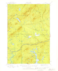
1925 Map of Pierce Pond
USGS Topo · Published 1925About this map
Coburn Mtn Lookout Station stands as a prominent high point in this mid-1920s survey of the Somerset County wilderness. The landscape is defined by an extensive network of remote ponds and high ridges, including Hurricane Mtn and Johnson Mtn. While permanent towns are absent, the map documents a specialized backcountry economy through scattered outposts like Grace Pond Camp, Depot Camp, and Salmon Stream Farm. Evidence of hydraulic management and logging transport is visible at Spencer Dam and Dead River Dam, where the Dead River flows toward Hayden Landing. Large geographic townships such as Upper Enchanted and Pierce Pond are delineated, showing a territory managed for timber and early wilderness recreation, evidenced by the clustered Otter Pond Camps in the southeast.
Find a feature on this map
80 named features on this map. Tap any name to fly to it.
Don’t see what you’re looking for? This feature index may not catch every label — zoom into the map to look around manually.
Map Details
Editions of this 1925 Pierce Pond Map
2 editions found
Other maps of this area

1903 · Bingham
USGS Topo · 1:62,500

1905 · Bingham
USGS Topo · 1:62,500

1905 · The Forks
USGS Topo · 1:62,500

1907 · The Forks
USGS Topo · 1:62,500

1921 · Brassua Lake
USGS Topo · 1:62,500

1922 · Long Pond
USGS Topo · 1:62,500

1923 · Brassua Lake
USGS Topo · 1:62,500

1923 · Attean
USGS Topo · 1:62,500

1924 · Long Pond
USGS Topo · 1:62,500

1925 · Attean
USGS Topo · 1:62,500
Featured Places
- West Forks, ME
- Hayden Landing, Pierce Pond Township
- Upper Enchanted Township, ME
- Johnson Mountain Township, ME
- Bowtown Township, ME